RouteMaster Mobile Client
Next-Generation Trip Planning & Execution Tool
What is RouteMaster?
"Are we there yet?"
If you’ve ever led a road trip, you know the drill. A passenger asks how far it is to that scenic viewpoint, the lunch spot, or the final stop. Suddenly, you’re trying to pinch-zoom on a cramped screen, tapping around to add temporary stops—all while keeping your eyes on the road.
What if, instead of wrestling with your map, the answer was always visible at a single glance?
“We’ll hit the mountain pass in 12 minutes, lunch in 45.”
That is RouteMaster.
Reclaiming the Joy of the Open Road
Most navigation apps treat driving like a chore—a problem to be solved by getting you from Point A to Point B as fast as humanly possible. They act like rigid turn-by-turn dictators.
RouteMaster isn’t a normal navigation app, even if it has that ability too. RouteMaster is a voyage planning and execution tool.
We built it on a simple philosophy: the journey should be just as rewarding as reaching the destination. Remember when planning a trip meant spreading out a paper map on the kitchen table, tracing scenic backroads, and building an itinerary you were actually excited to drive? RouteMaster brings that spirit back into the digital age. And it's a lot more than just nostalgia. It is built the way we humans work.
How It Works: The Psychology of Milestones
When you look at a 10-hour drive on a standard GPS driven map, your brain registers a monumental task. It’s exhausting before you even put the car in drive. And while it looks a bit cool with the icon resembling your vehicle on a moving map, it doesn't give you much valuable information, unless you stop to study it.
RouteMaster changes how your brain perceives travel through dynamic milestone tracking:
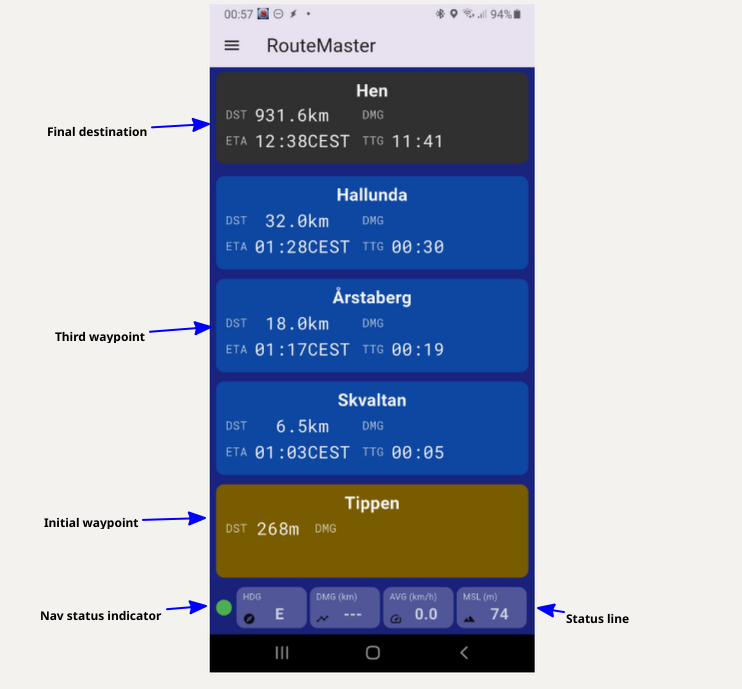
You are not locked to the waypoints being shown. You can scroll down to see upcoming waypoint all the way, until your final destination (always the top tile)
After a few seconds, after you release your finger from the display, it will return to the active waypoint being sat at the bottom.
To make the text as readable from a distance, as possible, we are using abbreviations for the type of information displayed:
- DST: Destination. How far is it to the given waypoint.
- DMG: Distance Made Good: How far along are we on the current leg.
- ETA: Estimated Time of Arrival: At what time will we be there.
- TTG: Time To Go: What is the duration until we're there.
- HDG: Heading: In which direction are we driving right now
- AVG: The average speed on this leg
- MSL: Mean Sea Level altitude: How high up are we, relative to the sea level.
The app has been designed, so it needs minimal human interaction during driving, so you can have all of your focus on the road.
You select your route by touching the top tile. Then a list of available routes are displayed to you in distance order. So the routes nearest your current position will always be at the top. For all routes with a common starting point, they will be sorted alphabetically.
Once you have selected your route, the trip is armed, but not started. The initial waypoint (your entry waypoint) will show amber/yellow. The trip starts when you hit that waypoint. Then it will turn green for a few seconds, before it disappears by dropping down below the "horizon". At that time, your trip will officially start, and all statistics will be calculated against this starting location and time.
Amenities:
As seasoned road-trippers, we know that there is more to it than just driving along and chugging kilometers (or miles). --We have bodies that need food, we need toilets and sometimes, believe it or not, we need to refuel our vehicles.
So we have made it as easy as possible to locate said amenities and display them as intermediate waypoints, just like the route waypoints.
The amenity selector is hidden in plain sight. You press the status-line, and you get a map displayed with your nearest waypoints displayed onto the map. If you select Fuel, you will get the 15 nearest fuel stations displayed along the route. We understand very well, that drivers don't like to turn around to find something. You want to look ahead. So even if we do search a tiny bit behind us, we are looking for matching locations that are as close to our waypoints as possible. That minimizes detours that will cost you both time and money.
When you have selected your amenity from the map, it will be inserted at the correct location in the itinerary, and it will show up in yellow, almost like the entry waypoint. It will carry the same information as the rest of the waypoint tiles. Distance and time estimates.
Help! I'm lost:
While RouteMaster is primarily an app for road-tripping and commute, where you generally know where you're going, sometimes you can get lost and need added guidance.
Maybe your entry waypoint is located somewhere where you don't know how to get to, or that fuel station is located in some industrial area. Don't dispair. Just press and hold the tile indicating the waypoint you want to drive to, and your turn-by-turn navigation app will show up, pre-loaded with that very destination. So, in other words: You get the best of both worlds. Guidance when it's needed, and a live itinerary when that is most appropriate.
Driving statistics:
Statistics is important to be able to predict your progress along the trip. Our system, while being anonymous, logs each leg traveled by vehicle type, season and time of day, to give you a good prediction of how long a leg will take to traverse. So each time you complete a leg, you will send this basic data to the cloud, so you can study it later using the add-on statistics tools, and others traveling that stretch of road can benefit from your performance.
From that statistical information, you will also get an indicator for how much behind (+red) you are, or how much ahead (-green) you are, on a given active leg, and the complete route. The ETA and TTG's are automatically updated with this correction.